
Analysis and Selection of the Best Global Geopotential Model for Lebanon
Case Study Rashya District
DOI:
https://doi.org/10.46604/emsi.2026.15489Keywords:
Analysis, Geoidal Global Models, Orthometric Heights, GISAbstract
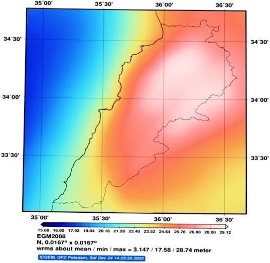
Accurate transformation of Global Positioning System (GPS) derived ellipsoidal heights to orthometric heights necessitates the selection of an optimal Global Geopotential Model (GGM). This study aims to identify the most accurate freely available high-resolution GGM for Lebanon. The performance of five GMs, Earth Gravitational Model 2008 (EGM2008), SGG_UGM_1, SGG_UGM_2, GECO, and XGM2019e, is assessed. Geoidal undulation values are extracted for 28 geodetic benchmarks in the Rashaya district using a Geographic Information System and compared with reference data from the Lebanese Directorate of Geodetic Affairs. Vertical accuracy is quantified using the mean deviation (DN), standard deviation, and root mean square error (RMSE) between GGM-derived and reference heights. The analysis reveals that XGM2019e provides the highest accuracy, with the smallest mean deviation (DN = –0.25 m) and the lowest RMSE (±1.09 m). These results establish XGM2019e as the optimal GGM for Lebanon, ensuring precise height transformation and supporting advanced geodetic and geospatial analyses.
References
K. Pakoksung and M. Takagi, “Assessment and Comparison of Digital Elevation Model (DEM) Products in Varying Topographic, Land Cover Regions and Its Attributes: A Case Study in Shikoku Island,” Japan,” Model Earth Syst Environ, vol. 7, pp. 465-484, 2021.
P. Maglione, C. Parente, and A. Vallario, “Accuracy of Global Geoid Height Models in Local Area: Tests on Campania Region (Italy),” International Journal of Civil Engineering and Technology, vol. 9, no. 3, pp. 1049-1057, 2018.
A. Fanos, T. Rusul, S. Mohammed, and M. Suad, “Calculating of Adjusted Geoid Undulation Based on EGM08 and Mean Sea Level for Different Regions in Iraq,” MATEC Web of Conferences, vol. 162, article no. 03028, 2018.
W. A. Heiskanen and H. Moritz, “Physical Geodesy,” Bulletin Géodésique, vol. 86, pp. 491-492, 1967.
C. J. Nyoka, A. H. M. Din, M. F. Pa'suya, and A. H. Omar, “Rigorous Evaluation of Global Geopotential Models for Geoid Modelling: A Case Study in Kenya,” Journal of African Earth Sciences, vol. 194, article no. 104612, 2022.
K. M. A. Aziz, K. S. Rashwan, and N. Saba, “Evaluation of EGM96 and EGM08 Based on GPS/Levelling Heights in Egypt,” South African Journal of Geomatics, vol. 12, no. 1, pp. 44-55, 2023.
S. Lee, C. Choi, and J. Kim, “Evaluating the Suitability of the EGM2008 Geopotential Model for the Korean Peninsula Using Parallel Computing on a Diskless Cluster,” Computers & Geosciences, vol. 52, pp. 132-145, 2013.
D. S. Fazilova, A. Kazakov, and I. M. Alimukhamedov, “Improving Global Geoid by GPS and Leveling Data Over the Fergana Valley Territory,” InterCarto. InterGIS, vol. 28, no. 1, pp. 568-579, 2022.
B. Erol, “An Automated Height Transformation Using Precise Geoid Models,” Scientific Research and Essays, vol. 6, no. 6, pp. 1351-1363, 2011.
M. Rabah, A. El-Hattab, and M. Abdallah, “Assessment of the Most Recent Satellite Based Digital Elevation Models of Egypt,” NRIAG journal of astronomy and geophysics, vol. 6, no. 2, pp. 326-335, 2017.
ICGEM, “ICGEM International Center for Global Earth Models,” http://icgem.gfz-potsdam.de/ICGEM/ICGEM.html, accessed in 2023.
M. S. Peprah, Y. Y. Ziggah, and I. Yakubu, “Performance Evaluation of the Earth Gravitational Model 2008 (EGM2008)–a Case Study,” South African Journal of Geomatics, vol. 6, no. 1, pp. 47-72, 2017.
Q. Liu, M. Schmidt, L. Sánchez, L. Moisés, and D. Cortez, “High-Resolution Regional Gravity Field Modeling in Data-Challenging Regions for the Realization of Geopotential-Based Height Systems,” Earth, Planets Space, vol. 76, no. 1, article no. 35, 2024.
L. Wei, X. U. Xinyu, L. I. Jiancheng, and Z. H. U. Guangbin, “The Determination of an Ultra-High Gravity Field Model SGG-UGM-1 by Combining EGM2008 Gravity Anomaly and GOCE Observation Data,” Acta Geodaetica et Cartographica Sinica, vol. 47, no. 4, article no. 425, 2018.
W. Liang, J. Li, X. Xu, S. Zhang, and Y. Zhao, “A High-Resolution Earth's Gravity Field Model SGG-UGM-2 from GOCE, GRACE, Satellite Altimetry, and EGM2008,” Engineering, vol. 6, no. 8, pp. 860-878, 2020.
J. M. Brockmann, T. Schubert, T. Mayer-Gürr, and W. D. Schuh, “The Earth's Gravity Field as Seen by the GOCE Satellite: an Improved Sixth Release Derived with the Time-Wise Approach (GO_CONS_GCF_2_TIM_R6),” GFZ Data Services, 2019.
A. Kvas, T. Mayer-Gürr, S. Krauß, J. M. Brockmann, T. Schubert, W. Schuh, et al., “The Satellite-Only Gravity Field Model GOCO06s,” GFZ Data Services, 2019.
P. Zingerle, R. Pail, T. Gruber, and X. Oikonomidou, “The Combined Global Gravity Field Model XGM2019e,” Journal of geodesy, vol. 94, no. 7, article no. 66, 2020.
Y. Wu, X. He, Z. Luo, and H. Shi, “An Assessment of Recently Released High-Degree Global Geopotential Models Based on Heterogeneous Geodetic and Ocean Data,” Frontiers in Earth Science, vol. 9, article no. 749611, 2021.
E. Nicacio, R. Dalazoana, and S. De Freitas, “Evaluation of the Ultra-High Resolution Global Geopotential Model SGG-UGM-1 in the Brazilian Southern Region,” in VII Simpósio Brasileiro de Ciências Geodésicas e Tecnologias da Geoinformação, pp. 609-618, 2018.
Google, “Google Earth,” https://satellites.pro/Google/Lebanon_map, accessed in 2023.
NASA, “Earth Data,” https://www.earthdata.nasa.gov/, accessed in 2023.
M. M. Gazizovich and M. Nasrullah, “Estimating Coordinates Transformation Parameters from Global to Local Coordinates Systems in Lebanese Republic Based on Zonal Division,” International Journal of Engineering, vol. 38, no. 4, pp. 796-806, 2025.
O. C. Ibe, Fundamentals of Applied Probability and Random Processes, 2nd ed., Academic Press, 2014.
A. J. Hayter, Probability and Statistics for Engineers and Scientists, 4th ed., Brooks/Cole: Cengage Learning, 2012.
T. G. Farr, P. A. Rosen, E. Caro, R. Crippen, R. Duren, S. Hensley, et al., “The Shuttle Radar Topography Mission,” Reviews of geophysics, vol. 45, no. 2, 2007.
E. Uuemaa, S. Ahi, B. Montibeller, M. Muru, and A. Kmoch, “Vertical Accuracy of Freely Available Global Digital Elevation Models (ASTER, AW3D30, MERIT, TanDEM-X, SRTM, and NASADEM),” Remote Sensing, vol. 12, no. 21, article no. 3482, 2020.
D. C. Montgomery and G. C. Runger, Applied Statistics and Probability for Engineers, 7th ed., Hoboken, NJ: Wiley, 2018.
Published
How to Cite
Issue
Section
License
Copyright (c) 2026 Mohamed Issa, Mohammad Abboud

This work is licensed under a Creative Commons Attribution-NonCommercial 4.0 International License.
Copyright Notice
Submission of a manuscript implies: that the work described has not been published before that it is not under consideration for publication elsewhere; that if and when the manuscript is accepted for publication. Authors can retain copyright in their articles with no restrictions. Also, author can post the final, peer-reviewed manuscript version (postprint) to any repository or website.
Since Sep. 01, 2023, EMSI will publish new articles with Creative Commons Attribution Non-Commercial License, under Creative Commons Attribution Non-Commercial 4.0 International (CC BY-NC 4.0) License.
The Creative Commons Attribution Non-Commercial (CC-BY-NC) License permits use, distribution and reproduction in any medium, provided the original work is properly cited and is not used for commercial purposes.