
Optimum Combinations of GGM and GDEM Models for Precise National Geoid Modelling
DOI:
https://doi.org/10.46604/peti.2021.6452Keywords:
GGM, DEM, GNSS, geoid, EgyptAbstract
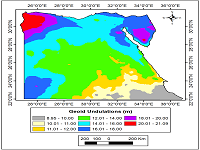
This study aims to develop a Local Geoid Model (LGM) for Egypt to determine the optimal combinations of global models with Global Navigation Satellite Systems (GNSS/Levelling) data. A precise national geodetic dataset, four Global Geopotential Models (GGMs), and three global Digital Elevation Models (DEMs) have been utilized. Hence, twelve gravimetric LGMs have been developed using the Least-Square Collocation (LSC) method fitted to GNSS/Levelling data and judged over 100 checkpoints. Results revealed that improvements in local geoid accuracy are attributed mainly to GGMs models representing the long wavelength of the Earth's gravitational field. Regarding DEMs, the accuracy of LGMs does not significantly depend on the utilized DEM. Based on the available data, the attained optimum geoid of Egypt has been developed with a standard deviation, equals 0.129 m.
References
K. M. Ahlgren, S. A. Holmes, X. Li, Y. M. WANG, and M. A. Youngman, “Geoid Modeling at NOAA’ s National Geodetic Survey as 2022 Approaches,” FIG Working Week, Helsinki, Finland, 2017.
M. Greaves, P. Downie, and K. Fitzpatrick, “OSGM15 and OSTN15: Updated Transformations for UK and Ireland,” Geomatics World, No. 32/33, pp. 1-5, 2016.
F. Duquenne and A. Coulomb, “The French Approach to Modernize Its Vertical Reference,” Finance Information Group Working Week, May 2015, pp. 17-21.
K. Matsuo and Y. Kuroishi, “Refinement of a Gravimetric Geoid Model for Japan using GOCE and An Updated Regional Gravity Ffield Model,” Earth, Planets and Space, vol. 72, no. 1, pp. 1-18, March 2020.
A. V. Fernádez, O. L. Castro, and J. G. León, “Geoid Heights in Costa Rica, Case of Study: Central Pacific Zone,” Revista Ingenieria, vol. 30, no. 1, pp. 1-20, November 2020.
M. El-Ashquer, H. Al-Ajami, A. Zaki, and M. Rabah, “Study on the Selection of Optimal Global Geopotential Models for Geoid Determination in Kuwait,” Survey Review, vol. 52, no. 373, pp. 373-382, May 2019.
M. E. Gomez, R. Perdomo, and D. Del Cogliano, “Validation of Recent Geopotential Models in Tierra Del Fuego,” Acta Geophysica, vol. 65, no. 5, pp. 931-943, September 2017.
A. A. Saad and M. S. Elsayed, “Evaluation of GOCE Satellite Only Models Along the River Nile,” Scientific and Academic Publishing, vol. 8, no. 3, pp. 131-140, 2019.
M. Eshagh and S. Zoghi, “Local Error Calibration of EGM08 Geoid using GNSS/levelling Data,” Journal of Applied Geophysics, vol. 130, pp. 209-217, July 2016.
D. S. Alnaggar, “Determination of the Geoid in Egypt Using Heterogeneous Geodetic Data,” PhD dissertation, Faculty of Engineering, Cairo University, 1986.
G. M. Dawod, “A National Gravity Standardization Network for Egypt,” PhD dissertation, Faculty of Engineering at Shoubra, Zagazig University, 1998.
H. Abd-Elmotaal, “Gravimetric Geoid for Egypt Using High-Degree Tailored Reference Geopotential Model,” National Research Institute of Astronomy and Geophysics Journal of Geophysics. Special issue, pp. 507-531, December 2008.
G. Dawod, W. Resrach, and T. M. Abdelaziz, “Utilization of Geographically Weighted Regression for Geoid Modelling in Egypt,” Journal of Applied Geodesy, vol. 14, no. 1, October, 2019.
T. Abdel-Aziz, G. Dawod, and H. Ebaid, “DEMs and Reliable Sea Level Rise Risk Monitoring in Nile Delta, Egypt,” Discover Sustainability, vol. 1, no. 1, pp. 1-11, December 2020.
P. Zingerle, R. Pail, and T. Gruber, “High-Resolution Combined Global Gravity Field Modelling--Towards a Combined d/o 10800 Model,” Geophysical Research Abstracts, vol. 21, January 2019.
M. Gilardoni, M. Reguzzoni, and D. Sampietro, “GECO: A Global Gravity Model by Locally Combining GOCE Data and EGM2008,” Studia Geophysica et Geodaetica, vol. 60, no. 2, pp. 228-247, March 2016.
C. Förste, S. Bruinsma, O. Abrikosov, F. Flechtner, J. C. Marty, J. M. Lemoine, et al., “EIGEN-6C4-The Latest Combined Global Gravity Field Model Including GOCE Data up to Degree and Order 1949 of GFZ Potsdam and GRGS Toulouse,” EGUGA, p. 3707, May 2014.
N. K. Pavlis, S. A. Holmes, S. C. Kenyon, and J. K. Factor, “The Development and Evaluation of the Earth Gravitational Model 2008 (EGM2008),” Journal of Geophysics Research Solid Earth, vol. 117, no. B4, April 2012.
“The International Center for Global Earth Model,” http://icgem.gfz-potsdam.de/tom_longtime, October 12, 2020.
“SRTMGL1 V003,” The US Geological Survey, https://lpdaac.usgs.gov/products/srtmgl1v003/, 2020.
R. Smith and P. Berry, “Altimeter Corrected Elevations, Version 2,” https://sedac.ciesin.columbia.edu/data/set/dedc-ace-v2, 2019.
“ASTER Digital Elevation Model V003,” https://catalog.data.gov/dataset/aster-digital-elevation-model-v003, July 17, 2020.
B. Hofmann-Wellenhof, “Moritz, H.(2005) Physical Geodesy”, New York: Springer, 1967.
R. Forsberg and C. C. Tscherning, GRAVSOFT: Geodetic Gravity Field Modelling Programs Manual, 2nd ed. Denmark: National Space Institute, 2008.
E. M. Al. Krargy, “Development of a National Geoid for Egypt Using Recent Surveying Data,” PhD dissertation, Faculty of Engineering, Minufiya university, Egypt, 2016.
Published
How to Cite
Issue
Section
License
Submission of a manuscript implies: that the work described has not been published before that it is not under consideration for publication elsewhere; that if and when the manuscript is accepted for publication. Authors can retain copyright of their article with no restrictions. Also, author can post the final, peer-reviewed manuscript version (postprint) to any repository or website.

Since Oct. 01, 2015, PETI will publish new articles with Creative Commons Attribution Non-Commercial License, under The Creative Commons Attribution Non-Commercial 4.0 International (CC BY-NC 4.0) License.
The Creative Commons Attribution Non-Commercial (CC-BY-NC) License permits use, distribution and reproduction in any medium, provided the original work is properly cited and is not used for commercial purposes