
Selection of Elevation Models for Flood Inundation Map Generation in Small Urban Stream: Case Study of Anyang Stream
DOI:
https://doi.org/10.46604/aiti.2023.12000Keywords:
urban flood inundation map, HEC-RAS 2D, DSM, DEM, terrain dataAbstract
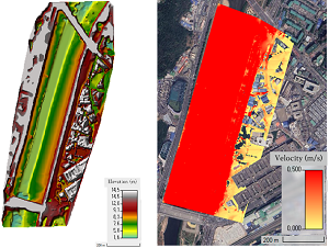
To reduce flood damages, the Ministry of Environment in Korea has provided a flood inundation map so that people can expediently identify flood-prone areas. However, the current flood inundation maps have been produced based on the DEM which makes it difficult to represent realistic situations due to the lack of reproduction of land surface conditions. This study aims to provide more accurate and detailed flood inundation maps for flooding events due to river overflow in small urban areas. In this study, flood inundation analysis is performed using the river analysis system, HEC-RAS 2D, with the DSM and the DEM of urban areas in the Anyang Stream Basin, Korea to examine the differences in terms of terrain data and flooded area. Finally, for urban areas with dense buildings and congested road networks, the flood inundation analysis based on DSM can represent a more realistic flood situation and create an appropriate flood inundation map.
References
World Meteorological Organization (WMO), WMO Bulletin, vol. 71, no. 1, Switzerland: WMO, 2022.
T. Kanitkar, A. Mythri, and T. Jayaraman, “Equity Assessment of Global Mitigation Pathways in the IPCC Sixth Assessment Report,” unpublished.
E. E. Koks, K. C. H. van Ginkel, M. J. E. van Marle, and A. Lemnitzer, “Brief Communication: Critical Infrastructure Impacts of the 2021 Mid-July Western European Flood Event,” Natural Hazards and Earth System Sciences, vol. 22, no. 12, pp. 3831-3838, November 2022.
I. H. Son, “Flood Risk Map Overseas Production Case,” Water for Future, vol. 45, no. 9, pp. 99-105, 2012. (In Korean)
S. U. Kim, K. W. Jun, S. H. Lee, and W. S. Pi, “Analysis of the Impact of Building Congested Area for Urban Flood Analysis,” Journal of Korean Society of Disaster and Security, vol. 15, no. 3, pp. 41-46, September 2022.
J. Y. Lee and S. R. Ha, “Impact of Building Blocks on Inundation Level in Urban Drainage Area,” Journal of Environmental Impact Assessment, vol. 22, no. 1, pp. 99-107, 2013.
D. H. Lee, K. W. Jun, and I. D. Kim, “A Study on the Production of Flooding Maps in Small Stream,” Journal of Korean Society of Disaster and Security, vol. 14, no. 2, pp. 51-59, June 2021.
S. Salunke and A. D. Thube, “Floodplain Mapping of Krishna River at Karad Using HEC-RAS,” International Research Journal of Engineering and Technology, vol. 9, no. 7, pp. 1444-1450, July 2022
“Ogeumgyo - Google Maps,” https://maps.app.goo.gl/bExCumDsTsX7ngJYA, January 10, 2023.
J. Wang, L. Wang, M. Jia, Z. He, and L. Bi, “Construction and Optimization Method of the Open-Pit Mine DEM Based on the Oblique Photogrammetry Generated DSM,” Measurement, vol. 152, article no. 107322, February 2020.
N. H. Pandjaitan, Sutoyo, M. I. Rau, J. Febrita, I. Dharmawan, and I. Akhmat, “Comparison between DSM and DTM from Photogrammetric UAV in Ngantru Hemlet, Sekaran Village, Bojonegoro East Java,” Proceedings of SPIE, Sixth International Symposium on LAPAN-IPB Satellite, vol. 11372, article no. 113723, 2019.
J. H. Yoon and G. H. Kim, “3D Building Mapping using Drone,” Korean Society of Surveying, Geodesy, Photogrammetry, and Cartography, pp. 101-102, 2020. (In Korean)
D. Halwatura and M. M. M. Najim, “Application of the HEC-HMS Model for Runoff Simulation in a Tropical Catchment,” Environmental Modelling & Software, vol. 46, pp. 155-162, August 2013.
Ministry of Land, Infrastructure and Transport, “Anyang River Master Plan,” Construction Technology Digital Library, Technical Report OTKCRK200735, December 2015. (In Korean)
E. Ghimire, S. Sharma, and N. Lamichhane, “Evaluation of One-Dimensional and Two-Dimensional HEC-RAS Models to Predict Flood Travel Time and Inundation Area for Flood Warning System,” ISH Journal of Hydraulic Engineering, vol. 28, no. 1, pp. 110-126, 2022.
S. H. Lee, D. S. Lee, J. M. Kim, and B. S. Kim, “Study on 2-D Urban Flood Inundation Analysis Using Digital Surface Model (DSM) and Digital Elevation Model (DEM),” KSCE Journal of Civil and Environmental Engineering Research, pp. 351-352, 2016. (In Korean)
G. H. Kim and G. T. Kim, “Development of Flood Damage Estimation Model (K-FRM) Analysis Tool to Support Economy Analysis,” Water for Future, vol. 54, no. 5, pp. 14-22, 2021. (In Korean)
D. J. Trieste and U. S. Bureau of Reclamation, “Downstream Hazard Classification Guidelines,” Denver: U.S. Department of the Interior Bureau of Reclamation, 1988.
Published
How to Cite
Issue
Section
License
Copyright (c) 2023 Chanjin Jeong, Dong-Hyun Kim, Hyung-Ju Yoo, Seung-Oh Lee

This work is licensed under a Creative Commons Attribution-NonCommercial 4.0 International License.
Submission of a manuscript implies: that the work described has not been published before that it is not under consideration for publication elsewhere; that if and when the manuscript is accepted for publication. Authors can retain copyright in their articles with no restrictions. is accepted for publication. Authors can retain copyright of their article with no restrictions.

Since Jan. 01, 2019, AITI will publish new articles with Creative Commons Attribution Non-Commercial License, under The Creative Commons Attribution Non-Commercial 4.0 International (CC BY-NC 4.0) License.
The Creative Commons Attribution Non-Commercial (CC-BY-NC) License permits use, distribution and reproduction in any medium, provided the original work is properly cited and is not used for commercial purposes.