
Mapping and Change Assessment of Captive Limestone Mining Areas Using Landsat-5/8 Images
DOI:
https://doi.org/10.46604/emsi.2023.11316Keywords:
change assessment, limestone mine, remote sensing, spectral indicesAbstract
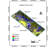
Limestone is a non-metallic mineral extensively used in cement manufacturing and construction sector. Extensive mineral mining processes impact the environment. The study aims to map and evaluate the limestone mining area change at the Yerraguntla industrial zone in the YSR district of Andhra Pradesh, India. The normalized difference vegetation index (NDVI) and modified soil-adjusted vegetation index (MSAVI) are computed from the Landsat-5/8 images using Quantum GIS (QGIS) software. Experimental results show that the limestone mining area increases from 307 ha to 469.92 ha during 2005-2019. NDVI method is more effective than MSAVI in change assessment of limestone mining areas with overall accuracy of 87.75 % and 79.49 % and kappa coefficient of 0.89 and 0.62 respectively in 2019. The finding is compared with industry field survey reports (487.10 ha). This study contributes to the limestone mining industry management in developing a land-environmental management plan for the long-term sustainability of limestone mining.
References
A. T. Lima, K. Mitchell, D. W. O’Connell, J. Verhoeven, and P. V. Cappellen, “The Legacy of Surface Mining: Remediation, Restoration, Reclamation and Rehabilitation,” Environmental Science & Policy, vol. 66, pp. 227-233, December 2016.
R. C. Rooney, S. E. Bayley, and D. W. Schindler, “Oil Sands Mining and Reclamation Cause Massive Loss of Peatland and Stored Carbon,” Proceedings of the National Academy of Sciences, vol. 109, no. 13, pp. 4933-4937, March 2012.
S. Li, J. Wu, Y. Huo, X. Zhao, and L. Xue, “Profiling Multiple Heavy Metal Contamination and Bacterial Communities Surrounding an Iron Tailing Pond in Northwest China,” Science of the Total Environment, vol. 752, article no. 141827, January 2021.
S. Gao, Y. Chen, K. Li, Y. Li, J. Yu, and R. Rao, “Mapping Opencast Iron Mine and Mine Solid Waste Based on a New Spectral Index from Medium Spatial Resolution Satellite Data,” IEEE Journal of Selected Topics in Applied Earth Observations and Remote Sensing, vol. 14, pp. 7788-7798, 2021.
J. Li, Y. Pei, S. Zhao, R. Xiao, X. Sang, and C. Zhang. “A Review of Remote Sensing for Environmental Monitoring in China,” Remote Sensing, vol. 12, no. 7, article no. 1130, April 2020.
A. A. Pericak, C. J. Thomas, D. A. Kroodsma, M. F. Wasson, M. R. V. Ross, N. E. Clinton, et al., “Mapping the Yearly Extent of Surface Coal Mining in Central Appalachia Using Landsat and Google Earth Engine,” Plos One, vol. 13, no. 7, article no. e0197758, 2018.
Andhra Pradesh Space Applications Centre, “District Survey Report-Ysr Kadapa District,” Department of Mines and Geology Government of Andhra Pradesh, District Survey Report, July 2021.
C. V. Sudhakar, G. U. Reddy, and N. U. Rani, “Delineation and Evaluation of the Captive Limestone Mining Area Change and Its Influence on the Environment Using Multispectral Satellite Images for Industrial Long-Term Sustainability,” Cleaner Engineering and Technology, vol. 10, article no. 100551, October 2022.
C. V. Sudhakar and G. U. Reddy, “Satellite Image Based Spatio-Temporal Variation Assessment in Captive Limestone Mines for Long-Term Viability,” Journal of Mobile Multimedia, vol. 18, no. 3, pp. 635-660, January 2022.
C. V. Sudhakar and G. U. Reddy, “Land Use Land Cover Change Assessment at Cement Industrial Area Using Landsat Data-Hybrid Classification in Part of YSR Kadapa District, Andhra Pradesh, India,” International Journal of Intelligent Systems and Applications in Engineering, vol. 10, no. 1, pp. 75-86, March 2022.
D. S. Bona, A. M. Arymurthy, and P. Mursanto, “Classification of Limestone Mining Site Using Multi-Sensor Remote Sensing Data and OBIA Approach a Case Study: Biak Island, Papua,” International Conference on Advanced Computer Science and Information Systems, pp. 417-422, October 2018.
D. Paull, G. Banks, C. Ballard, and D. Gillieson, “Monitoring the Environmental Impact of Mining in Remote Locations through Remotely Sensed Data,” Geocarto International, vol. 21, no. 1, pp. 33-42, 2006.
S. Bürck, “Remote Sensing Analyses for Open Pit Mine Area Computation. A Comparative Study on the Implementation of Multi-Spectral Classifications and Crowdsourcing to Compute the Spatial Extent of Four Open-Pit Mines in Indonesia, Australia, Canada and Brazil,” Ph.D. dissertation, Faculty of Chemistry and Earth Sciences, Institute of Geography, Heidelberg University, Heidelberg, 2020.
S. Rajendran, S. Nasir, M. A. El-Ghali, K. Alzebdah, A. S. Al-Rajhi, and M. Al-Battashi, “Spectral Signature Characterization and Remote Mapping of Oman Exotic Limestones for Industrial Rock Resource Assessment,” Geosciences, vol. 8, no. 4, article no. 145, April 2018.
V. S. D. Silva, G. Salami, M. I. O. D. Silva, E. A. Silva, J. J. M. Junior, and E. Alba, “Methodological Evaluation of Vegetation Indexes in Land Use and Land Cover (LULC) Classification,” Geology, Ecology, and Landscapes, vol. 4, no. 2, pp. 159-169, 2020.
G. M. Gandhi, S. Parthiban, N. Thummalu, and A. Christy, “NDVI: Vegetation Change Detection Using Remote Sensing and GIS – A Case Study of Vellore District,” Procedia Computer Science, vol. 57, pp. 1199-1210, 2015.
A. Madasa, I. R. Orimoloye, and O. O. Ololade, “Application of Geospatial Indices for Mapping Land Cover/Use Change Detection in a Mining Area,” Journal of African Earth Sciences, vol. 175, article no. 104108, March 2021.
J. Qi, A. Chehbouni, A. R. Huete, Y. H. Kerr, and S. Sorooshian, “A Modified Soil Adjusted Vegetation Index,” Remote Sensing of Environment, vol. 48, no. 2, pp. 119-126, May 1994.
C. Fan, B. He, P. Kong, H. Xu, Q. Zhang, and X. Quan, “Predicting 1-H Dead Fuel Moisture Content at Regional Scales Using Machine Learning from Himawari-8 Data,” IEEE International Geoscience and Remote Sensing Symposium IGARSS, pp. 1222-1225, July 2021.
D. Poursanidis, N. Chrysoulakis, and Z. Mitraka, “Landsat 8 vs. Landsat 5: A Comparison Based on Urban and Peri-Urban Land Cover Mapping,” International Journal of Applied Earth Observation and Geoinformation, vol. 35, no. part B, pp. 259-269, March 2015.
C. V. Sudhakar, G. U. Reddy, and N. U. Rani, “In Situ Measurement and Management of Soil, Air, Noise and Water Pollution in and Around the Limestone Mining Area of Yerraguntla, YSR Kadapa, Andhra Pradesh, India for the Sustainable Development,” Journal of Applied and Natural Science, vol. 14, no. 3, pp. 746-761, 2022.
Published
How to Cite
Issue
Section
License
Copyright Notice
Submission of a manuscript implies: that the work described has not been published before that it is not under consideration for publication elsewhere; that if and when the manuscript is accepted for publication. Authors can retain copyright in their articles with no restrictions. Also, author can post the final, peer-reviewed manuscript version (postprint) to any repository or website.
Since Sep. 01, 2023, EMSI will publish new articles with Creative Commons Attribution Non-Commercial License, under Creative Commons Attribution Non-Commercial 4.0 International (CC BY-NC 4.0) License.
The Creative Commons Attribution Non-Commercial (CC-BY-NC) License permits use, distribution and reproduction in any medium, provided the original work is properly cited and is not used for commercial purposes.