
Modeling and Forecasting Urban Sprawl in Sylhet Sadar Using Remote Sensing Data
DOI:
https://doi.org/10.46604/peti.2023.9617Keywords:
geographic information system, remote sensing, land use and land cover, urban sprawl, ordinary least square regression, cellular automataAbstract
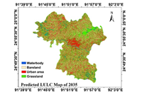
Forecasting urban sprawl is important for land-use and transport planning. The aim of this study is to model and predict the future urban sprawl in Sylhet Sadar using remote sensing data. The ordinary least square (OLS) regression model and the geographic information system (GIS) are used for modeling urban expansion. The model is calibrated for the years 2014 to 2017 using eight explanatory variables extracted from the regression model. The regression coefficients of the variables are found statistically significant at a 99% confidence level. The cellular automata (CA) model is then used to analyze, model, and simulate the land-use and land-cover (LULC) changes by incorporating the algorithm of logistic regression (LR). The calibrated model is used to predict the 2020 map, and the result shows that the predicted map and the actual map of 2020 are well agreed. By using the calibrated model, the simulated prediction map of 2035 shows an urban cell expansion of 220% between 2020 and 2035.
References
Z. Shao, et al., “Urban Sprawl and Its Impact on Sustainable Urban Development: A Combination of Remote Sensing and Social Media Data,” Geo-Spatial Information Science, vol. 24, no. 2, pp. 241-255, July 2021.
T. Firman, “Land Conversion and Urban Development in the Northern Region of West Java, Indonesia,” Urban Studies, vol. 34, no. 7, pp. 1027-1046, June 1997.
A. M. Youssef, et al., “Integrated Evaluation of Urban Development Suitability Based on Remote Sensing and GIS Techniques: Contribution from the Analytic Hierarchy Process,” Arabian Journal of Geosciences, vol. 4, no. 3, pp. 463-473, February 2010.
T. Angotti, Metropolis 2000: Planning, Poverty, and Politics, 1st ed., England: Routledge, 1993.
B. Batsuuri, et al., “Estimating the Impact of Urban Planning Concepts on Reducing the Urban Sprawl of Ulaanbaatar City Using Certain Spatial Indicators,” Land, vol. 9, no. 12, Article no. 495, December 2020.
B. Jiang, et al., “Geospatial Analysis and Modeling of Urban Structure and Dynamics: An Overview,” GeoJournal Library, vol. 99, pp. 3-11, 2010.
M. H. Bazai, et al., “Assessment of Urban Sprawl and Land Use Change Dynamics through GIS and Remote Sensing in Quetta, Balochistan, Pakistan,” Journal of Geography and Social Sciences, vol. 2, no. 1, pp. 31-50, June 2020.
X. Yang, et al., “Modelling Urban Growth and Landscape Changes in the Atlanta Metropolitan Area,” International Journal of Geographical Information Science, vol. 17, no. 5, pp. 463-488, July 2003.
P. H. Verburg, et al., “Dynamic Simulation of Land-Use Change Trajectories with the CLUE-s Model,” GeoJournal Library, vol. 90, pp. 321-335, 2007.
M. J. B. Alam, et al., “Unplanned Urbanization: Assessment through Calculation of Environmental Degradation Index,” International Journal of Environmental Science and Technology, vol. 3, no. 2, pp. 119-130, April 2006.
S. Gupta, et al., “Analysis of Impervious Land-Cover Expansion Using Remote Sensing and GIS: A Case Study of Sylhet Sadar Upazila,” Applied Geography, vol. 98, pp. 156-165, June 2018.
United Nations Population Fund, “Independent Country Programme Evaluation Annexes Bangladesh,” https://www.unfpa.org/sites/default/files/admin-resource/Bangladesh_CPE_Final_Report_Annexes.pdf, 2016.
Bangladesh Bureau of Statistics (BBS), “Bangladesh Bureau of Statistics (BBS): Area, Population and Literacy Rate by Paurashava—2001,” http://203.112.218.65:8008/WebTestApplication/userfiles/Image/LatestReports/YB2011.pdf, September 2012.
S. Leyk, et al., “Two Centuries of Settlement and Urban Development in the United States,” Science Advances, vol. 6, no. 23, pp. 1-12, June 2020.
D. Aldogom, et al., “Multi Temporal Satellite Images for Growth Detection and Urban Sprawl Analysis; Dubai City, UAE,” Remote Sensing Technologies and Applications in Urban Environments IV, vol. 11157, pp. 71-81, October 2019.
Q. He, et al., “Comparison of Urban Growth Patterns and Changes between Three Urban Agglomerations in China and Three Metropolises in the USA from 1995 to 2015,” Sustainable Cities and Society, vol. 50, Article no. 101649, October 2019.
M. H. Rahman, “Unplanned Urbanization and Hill Cutting: A Study on Environmental Change in Sylhet,” Brac University Journal, vol. 8, no. 1-2, pp. 13-21, 2011.
A. Haque, et al., “Study on Land Use Pattern Change and Its Causes,” International Journal of Environmental Research, vol. 2, no. 2, pp. 199-204, April 2008.
R. Hamad, “A Remote Sensing and GIS-Based Analysis of Urban Sprawl in Soran District, Iraqi Kurdistan,” SN Applied Sciences, vol. 2, no. 1, pp. 1-9, December 2019.
I. Santé, et al., “Cellular Automata Models for the Simulation of Real-World Urban Processes: A Review and Analysis,” Landscape and Urban Planning, vol. 96, no. 2, pp. 108-122, May 2010.
A. A. Al-Sharif, et al., “Monitoring and Predicting Land Use Change in Tripoli Metropolitan City Using an Integrated Markov Chain and Cellular Automata Models in GIS,” Arabian Journal of Geosciences, vol. 7, no. 10, pp. 4291-4301, October 2014.
C. Losiri, et al., “Modeling Urban Expansion in Bangkok Metropolitan Region Using Demographic-Economic Data through Cellular Automata-Markov Chain and Multi-Layer Perceptron-Markov Chain Models,” Sustainability, vol. 8, no. 7, Article no. 686, July 2016.
L. Sang, et al., “Simulation of Land Use Spatial Pattern of Towns and Villages Based on CA-Markov Model,” Mathematical and Computer Modelling, vol. 54, no. 3-4, pp. 938-943, August 2011.
A. Khan, et al., “Machine Learning-Based Monitoring and Modeling for Spatio-Temporal Urban Growth of Islamabad,” The Egyptian Journal of Remote Sensing and Space Science, vol. 25, no. 2, pp. 541-550, August 2022.
S. C. K. Tekouabou, et al., “Reviewing the Application of Machine Learning Methods to Model Urban Form Indicators in Planning Decision Support Systems: Potential, Issues and Challenges,” Journal of King Saud University—Computer and Information Sciences, in press.
M. Bosch, et al., “Addressing Urban Sprawl from the Complexity Sciences,” Urban Science, vol. 3, no. 2, Article no. 60, June 2019.
Z. Ma, et al., “Tau Coefficients for Accuracy Assessment of Classification of Remote Sensing Data,” Photogrammetric Engineering and Remote Sensing, vol. 61, no. 4, pp. 435-439, 1995.
T. Fung, et al., “The Determination of Optimal Threshold Levels for Change Detection Using Various Accuracy Indices,” Photogrammetric Engineering and Remote Sensing, vol. 54, no. 10, pp. 1449-1454, 1988.
D. C. Montgomery, et al., Introduction to Linear Regression Analysis, 3rd ed., New York: John Wiley & Sons, 2001.
J. R. Landis, et al., “The Measurement of Observer Agreement for Categorical Data,” Biometrics, vol. 33, no. 1, pp. 159-174, March 1977.
Published
How to Cite
Issue
Section
License
Submission of a manuscript implies: that the work described has not been published before that it is not under consideration for publication elsewhere; that if and when the manuscript is accepted for publication. Authors can retain copyright of their article with no restrictions. Also, author can post the final, peer-reviewed manuscript version (postprint) to any repository or website.

Since Oct. 01, 2015, PETI will publish new articles with Creative Commons Attribution Non-Commercial License, under The Creative Commons Attribution Non-Commercial 4.0 International (CC BY-NC 4.0) License.
The Creative Commons Attribution Non-Commercial (CC-BY-NC) License permits use, distribution and reproduction in any medium, provided the original work is properly cited and is not used for commercial purposes